Western Azerbaijan
Iravan Khanate
The Iravan Khanate, established on historical Azerbaijani lands in the mid-18th century, covered the territory between Azerbaijan's Mount Ağri (Ararat) and Mount Alagöz (Alayaz), stretching along both banks of the Araz River. It bordered Pambak Province, Shamshaddil and Gazakh sultanates, and Ganja Khanate to the north; Karabakh and Nakhchivan Khanates to the east; Khoy and Maku Khanates along with the Bayazid Pashalik to the south; and both the Kars Pashalik to the west and Shorayel Sultanate to the northwest. The total area of the Iravan Khanate was approximately 23,800 square kilometers.
From the early 15th century until the establishment of the Iravan Khanate, the territory was ruled by leaders of the Saadli tribe, part of the Qaraqoyunlu tribal federation. Due to its geographical position, it was called Chukhur-Saad, meaning "Saad’s Hollow."
After the Safavis state was founded in 1501, the Azerbaijani territory was administratively divided into four beylerbeyliks, including the Chukhur-Saad Beylerbeylik. Its administrative center was the city of Iravan, also known as the Iravan Beylerbeylik. At times, the Chukhur-Saad Beylerbeylik fell under the control of the Ottoman Empire and was recognized as the Iravan Province.
According to the "Müfəssəl dəftər" (Detailed Register) of 1590, the Iravan province comprised the Iravan region, which included 10 districts (nahiyas), and the Nakhchivan region, which had 16 districts and one area (qaza).
The "Summary Register of the Iravan Province" compiled in 1728 indicated the administrative-territorial division of the province as follows: Iravan city, Qirkhbulag, Karbi, Maku, Khinzirak, Garni, Vedi, Darachichak, Abaran, Goycha, Daralayaz, Mazra, Surmali, Ighdir, Araliq, Sharur nahiyas, and Shorayel (Shuragal) along with Nakhchivan sanjaks.
During the reign of Nadir Shah (1736-1747), the Iravan province was part of the Azerbaijani Beylerbeylik. Following Nadir Shah's assassination, the Afsharid Empire disintegrated, leading to the emergence of independent khanates. Like other Azerbaijani khanates, the Iravan Khanate was administratively divided into districts (mahals), which were further subdivided into villages.
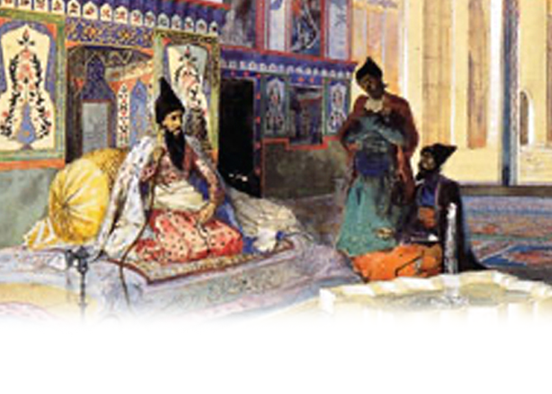
The city of Iravan was regarded as a separate administrative-territorial unit. The center of the khanate was Iravan, with the Iravan fortress itself serving as a grand architectural complex, acting both as a fortress and a city.
The administrative system of the Iravan Khanate and the city of Iravan resembled that of other Azerbaijani khanates of the period. The official state language of the khanate was Azerbaijani Turkish, while Persian was used in official correspondence when necessary.
In the Iravan Khanate, which developed rich traditions of statehood, the ruling administration was primarily composed of Azerbaijanis. The small Armenian population living within the khanate was not represented in governance and was regarded merely as ordinary taxpayers.
The Iravan Khanate, which exhibited characteristics of sovereign statehood and was regarded as a typical feudal state, had its supreme authority—legislative, executive, and judicial power—vested in the khan (or sardar), in modern terms. The khan was typically appointed by the central authority, namely the shah.
The khan held exclusive authority to decide on the most critical matters affecting the nation's fate. George Bournoutian notes that the khan structured his administration like a central government, assigning responsibilities across civil, military, and religious sectors. The khan's family or court operated as a separate entity and could be regarded as a fourth branch of governance.
The economic affairs of the khanate were overseen by the vizier, regarded as the second most important figure after the khan. Despite his extensive powers, the khan was advised by a special consultative body known as the divan or khan’s council. This council included the khan, the vizier, key palace officials, and the Sheikh-ul-Islam. Typically led by the divanbeyi, the most trusted and influential person near the khan, the divan comprised up to 100 officials. Within the khan's palace, various officials managed different sectors alongside the vizier: sarkar-ali – who oversaw financial affairs, eshikaghasi – who handled palace household matters, khazinadar – who headed the treasury, sandiqdaraghasi – who supervised treasury revenues and expenditures, anbardaraghasi – who managed the storage of collected goods, and gorugbashi – who led the palace guards. Additional roles existed as well. The security service played a vital role in ensuring the khan’s orders were promptly executed and in maintaining law and order across the country. Musails were responsible for implementing the khan’s directives and judicial decisions. At the local level, darghas were tasked with collecting taxes on agricultural products.
The city of Iravan was designated as a separate administrative unit within the khanate. The position of city chief was held by a naib (viceroy) appointed by the khan, who was responsible for economic and administrative affairs, including the timely collection of taxes. If the khan temporarily departed the city, the naib assumed complete governance of it. As Iravan was a fortress city, the responsibility for maintaining order within the fortress and overseeing its defense was assigned to the qalabeyi (fortress commander). Law and order in the city were managed by the dargha (the police chief), with captains (yüzbaşılar) and sergeants (onbaşılar, yasavullar) working under the dargha's authority.
District administrators, known as mirboluks, were appointed by the khan (or the commander) and chosen from influential beys and other high-ranking members of society. Villages were managed by kandkhudas (village heads) or kokhas (village leaders), appointed by the mirboluks.
High-level guests from foreign countries were ceremoniously welcomed and bid farewell with official rituals by the khan of Iravan.
The khan pursued an independent foreign policy, declaring war on neighboring states when deemed necessary and dispatching troops to aid his allies. The khan's regular army consisted of two infantry regiments, cavalry, several 6-pound field cannons, and zambaraks (small cannons mounted on camels). When required, every able-bodied individual in the khanate's territory was conscripted into the army. Additionally, special artillery pieces were stationed on the fortress towers. During the reign of the last khan of Iravan, Huseyngulu Khan, his brother Hasan Khan served as the commander-in-chief of the army.
As in all Muslim states, a Sharia court also existed in the Iravan Khanate, made up of the Sheikh-ul-Islam, Qadi, and high-ranking religious leaders who handled civil disputes.
The education system in the Iravan Khanate resembled that of other Azerbaijani khanates, with religious leaders primarily responsible for education. Each mosque housed an attached madrasa (religious school).
In 1795, Agha Mohammad Khan Qajar brought the Iravan Khanate under his control and issued a special decree placing the regions of Shorayel and Pambak under the authority of Iravan’s Khan, Mahammad Khan.
On the eve of the 1827 Russian invasion of the Iravan Khanate, the administrative-territorial division of the khanate consisted of 15 districts (mahals) and the semi-dependent Shorayel sultanate. The districts (mahals) were as follows: 1. Qirkhbulag, 2. Zangibasar, 3. Garnibasar, 4. Vedibasar, 5. Korpubasar, 6. Sardarabad, 7. Talin, 8. Saadli, 9. Abaran, 10. Seyidli-Aghsaqqalli, 11. Darachichak, 12. Goycha, 13. Sharur, 14. Darakand-Parchenis, 15. Surmali.
Only two of the districts - Darakand-Parchenis and Surmali - were located on the right bank of the Araz River.
During the formation of districts (mahals), the availability of irrigation systems and the proximity of villages to river basins were the primary criteria.
The ethnic composition of the Iravan Khanate's population consisted of Oghuz-Turkic tribes. Historical sources indicate that the main population of the khanate was comprised of tribes belonging to the Qaraqoyunlu, Aqqoyunlu, and Qizilbash tribal federations, including: Bayat, Afshar, Saadli, Baharli, Bayandur, Qajar, Shamli, Rumlu, Ustajli, Tekeli, Ayrimli, Mughanli, and others.
The Üçkilsə (Echmiadzin) catholicoses, taking advantage of the patronage of the Qaraqoyunlu, Aqqoyunlu, and Safavi states, along with their European supporters, led the resettlement of Armenians in this fertile Azerbaijani region. Supported financially by Christian states and missionaries, Armenian churches accumulated wealth and acquired new lands from local Muslim rulers. Through these means, Armenians gradually established new settlements on Azerbaijani lands.
The lack of accurate information regarding the population of the Iravan Khanate in historical literature primarily stems from the numerous wars that occurred in the region. The conflicts between the Ottoman Empire and the Safavid and Afshar empires over control of the Iravan Khanate significantly affected the ethnic composition of the population.
In 1801, after Russian troops occupied the Pambak province located on the northern border of the Iravan Khanate, and again in 1804 when they seized the Shorayel sultanate, the forced deportation of Azerbaijanis began, accompanied by a mass influx of Armenians into these territories. Before the Russian occupation of Pambak and Shorayel, there were 200 Azerbaijani settlements in the region. However, by the early 19th century, 190 of these villages had been cleansed of Azerbaijanis. Following the Treaty of Gulistan in 1813, which transferred some territories of the Iravan Khanate to Russian control, Armenians were settled in Azerbaijani villages that had been emptied due to the war. During this period alone, more than 32,000 Armenians were relocated from the Ottoman Empire to the Pambak-Shorayel region.
James Morier, the secretary of the British embassy in Qajar Iran, visited Iravan in 1813 and estimated that the population of the khanate was around 100,000 people. This information was later confirmed by Russian sources.
Additionally, Semyon Bronevski, who served as the director of the Asian Department of the Russian Ministry of Foreign Affairs in the early 19th century, reported that 18,000 families lived in the Iravan Khanate.
A relatively accurate account of the population of the Iravan Khanate can be found in the book "Исторический памятник состояния Армянской области в эпоху её присоединения к Российской империи" (Historical Monument of the State of the Armenian Province at the Time of Its Annexation to the Russian Empire), written by Ivan Chopin and published in St. Petersburg in 1852. This work was based on the cameral census conducted in the khanate between 1829 and 1832. The fact that the translator accompanying Chopin was Armenian influenced how the ethnic composition was recorded, often favoring the Armenians. Moreover, the historical summary provided by Chopin at the beginning of the book relied heavily on the works of Armenian authors, which in some instances hindered him from reaching objective conclusions. Nevertheless, Chopin's work is regarded as a detailed source of information about the Iravan Khanate.
According to the information provided by the author, before the invasion, there were 831 villages in the territory of the Iravan Khanate, of which 310 were destroyed as a result of the war. Considering an average of 25 families per village, with 5-6 people per family, it can be estimated that over 43,000 people lived in the 310 destroyed villages. According to Chopin's data, after the invasion, 7,331 Muslims were recorded in the city of Iravan and 57,364 Muslims in the districts. However, there were actually 16,000 Muslims living in Iravan city before the invasion. If we add the 43,000 people from the destroyed villages to these numbers, it becomes clear that at least 116,000 Muslims lived in the Iravan Khanate before the invasion. Regarding the Armenians, Chopin mentions that there were 20,073 Armenians in the districts and 2,369 in the city of Iravan, totaling 22,442 Armenians. Many of these 22,442 Armenians were not locals, but had settled in the region following the wars that occurred in the Khanate since 1804, coming from Türkiye. Nevertheless, in percentage terms, before the invasion, Armenians constituted about 19% of the total population of the Khanate.
The American researcher of Armenian descent, George Bournoutyan, also examined the results of I. Chopin's cameral survey and concluded that before the invasion, approximately 20,000 Armenians lived in the Iravan Khanate, which comprised 20% of the total population.
I. Chopin's insights on the various social classes within the Iravan Khanate reveal the demographics of the indigenous population of the khanate. The results of the cameral survey indicated that there were 270 Muslim khan and bey families, considered nobility, and 30 Armenian malik and aga families recorded in the Iravan Khanate. This suggests that Armenian aristocrats made up only 10% of the total aristocracy in the khanate.
However, even after the invasion of the Iravan Khanate by Russian troops in 1827, Azerbaijanis remained numerically superior to Armenians in the region for a time. It was only after the Treaty of Turkmenchay (1828) and the Treaty of Edirne (Adrianople 1829), which facilitated the mass migration of Armenians from Iran and Türkiye to the Iravan Khanate, that the demographic landscape changed in favor of the Armenians.
Due to the resettlement policy of Tsarist Russia, Armenians were predominantly settled in Azerbaijani villages. Consequently, although Azerbaijanis became a minority compared to Armenians, the Azerbaijani settlements outnumbered those of the Armenians. According to data from 1865, in the Iravan province, out of 1,198 villages, 694 were inhabited by Muslims, 413 by Armenians, 10 by Russians, and in 91 villages, Armenians and Muslims lived together.
After the occupation, Azerbaijanis continued to make up the majority in the Iravan district, which surrounded the city of Iravan like a ring and was considered the central area of the province. In 1865, out of the 79,661 people registered in the district, 46,617 were Azerbaijanis (Tatars), and 26,709 were Armenians. In other words, Azerbaijanis comprised 58.5% of the population, while Armenians accounted for 33.5%.
At the beginning of the 20th century, Azerbaijanis still made up the majority of the population in the Iravan district. At that time, the total population of the district was 121,809, of which 65,871 were Azerbaijanis, 45,624 were Armenians, 7,865 were Kurds, and 869 were Russians. In percentage terms, Azerbaijanis constituted 54.1% of the population, Armenians 37.5%, Kurds 6.5%, and Russians 0.7%.
The facts listed above further demonstrate that the indigenous population of the Iravan Khanate was primarily composed of Azerbaijani Turks, while Armenians migrated to the region through various means starting from the Middle Ages. The assertions made by Armenian historians that the territory of the Iravan Khanate was ancient Armenian land and that the majority of its population was Armenian are clearly unfounded, as evidenced by the figures provided above.
All these points lead to the conclusion that the Iravan Khanate had a well-developed administrative system rooted in statehood traditions.
Nazim Mustafa
Doctor of Philosophy in History